Please click on this image/link to access the visitors geologs:
You need to select a point in the map first...
Please note that the predictions are not from the map location.
The model is running ONLY for DEMONSTRATION purposes.
Adittional info about yieldSAFE model:
The model is running daily dor 3 years in a soil with 60 cm with medium-fine texture.
The model is simulating soil water content with NO groundcover.
The model HAS NOT YET been calibrated NOR validated.
The daily climate dataset was taken from NIWA website. From Hokitika Airport
If data is available, the climate dataset can be selected dinamicaly according to location
For now, the model is just set up for demonstration.
Calibration for Pinus radiata is the next step to explore biophysical variables
Benefits of Land use change to Forest:
Drag the icon in the map to any location in NZ. Results will be shown here...
Description
Current
To
Score
Land cover
MAI300(m3/ha/y)
---
CarbonY30(ton/ha)
---
Benefits on Erosion(ton/ha)
Benefits on Nitrogen Leaching(kg/ha)
Soil Water Content
???
???
Benefits on Biodiversity
???
???
???
Benefits on Streams quality
???
???
???
Predictions with climate change
Drag the icon in the map to any location in NZ. Results will be shown here...
Description
Current
Future with CC
Score
MAI300(m3/ha/y)
CarbonY30(ton/ha)
Benefits on Erosion(ton/ha)
???
???
Benefits on Nitrogen Leaching(kg/ha)
???
???
Soil Water Content
???
???
???
Benefits on Biodiversity
???
???
???
Benefits on Streams quality
???
???
???
HelpDesk
HELP boxes
WEFES contains these boxes that we try to populate with useful info
Whenever the mouse becomes an '?' sign, please click on it and help info will be shown about the element you clicked.
MAI300
This is a volume productivity index measured in m3/ha at age 30 with stocking of 300 stems per hectare (Kimberley 2005).
WEFES calculates the MAI300 at any point using a multiple regression model developed by Palmer (ref) containing a range of environmental variables'
average temp, lenz class, soil nutrient status, and soil water balance. The model has an R2 of xxx and an RMS of x.xm3/ha/yr.
Carbon
Total carbon stock in tonnes/ha at age 30 is calculated from the MAI300 index values using a simple conversion factor of volume and wood density of 300 kg/m3. Future versions will use the Forest Carbon Predictor (Beets at al) that generates carbon values for all four standard IPCC stand components stem, branches, foliage, roots.
Soil Erosion
The four class erosion susceptibility rating from the MfE National Environmental Standard (Bloomberg et al 2011) is used to define low, medium, high and very high susceptibility. This susceptibility is based on inherent soil and geomorphological characteristics and not vegetation cover. Look up tables were then generated by relating susceptiblity class to land cover and where existing landcover was woody vegetation the erosion susceptibility class was adjusted to low, in all other land use classes susceptibility was kept the same as the original category. This allows change in susceptibility from land use change to be characterized.
Refs:
Bloomberg M, Davies T, Visser R, Morgenroth J, 2011, Erosion Susceptibility Classification and Analysis of Erosion Risks for Plantation Forestry. Ministery for the Environment of New Zealand Available here
Nitrogen leaching
Nitrogen leaching rates vary depending on the intensity of land use with generally higher rates the higher the intensity of land use. Average N leaching rates for different land uses summarized in Meneer et al 2008 were associated with the appropriate Landcover data base classes to give a picture of expected leaching rate under the range of classes in the land cover database. Additionally, we varied the nitrate leaching from minimum to maximum according to precipitation tresholds (Fig 1).
The change in leaching rate with land use change was calculated by subtracting the leaching rate under the existing rate from that expected from the new land use. This change is then shown as a positive or negative value.
Figure 1
Biodiversity (Not yet implemented)
The map of native biodiversity loss (Hock et al in prep) is used as the base for identifiying the level of benefit from afforestation. A benefit scale of Low (>XX% remaining) , Medium (XX-XX% remaining), High (XX-XX% remaining) and Very High (0-XX% remaining) is used corresponding to the loss category associated with any point. The inverse would apply if deforestation occurred.
Datasets Info - Transparency - See what's in the database
One of the interests in WEFES is to see what are the values behind the calculations. Not only it serves to understand the calculations background, but also serves to simply display different sets of data for a single location which otherwise would be spread in individual studies and/or sources.
Because the retrieval of the current values for each coordinate is part of the calculation itself, there is no extra processing effort. A display of this intermediate data is simple and improves transparency of the calculations. This is easily consulted in the 'Datasets info' accordion tab in the interface, which can include additional information such as a link to a photo library for ease of understanding of the current analysis. Differences between land use and its impact on environmental services
Overall Score
The overall score is a weighted average (default is same weight for every environmental service) of all the calculate scores
The user can control the weights in the "Env. Services Weights" in a tab on the left
MAI300 Score
This score frames the model result within a minimum and a maximum value. Information on forest productivity was gathered and enabled to set 5 and 50 m3 ha-1 year-1 for MAI minimum and maximum respectively (Watt et al., 2010). Any value resulting from the used MAI300 model (Watt et al., 2010) is linearly interpolated in this range, providing a reference on how good is the service in a particular location.
Refs:
Watt, M.S., Palmer, D.J., Kimberley, M.O., Hock, B.K., Payn, T.W., Lowe, D.J., 2010. Development of models to predict Pinus radiata productivity throughout New Zealand. Canadian Journal of Forest Research-Revue Canadienne De Recherche Forestiere 40(3) 488-499. DOI
MAI300
Set the threshold of MAI300 (Watt et all, 2010) and Icons with MAI300 value will be spread in the map when "RUN FESF!" is clicked.
Refs:
Watt, M.S., Palmer, D.J., Kimberley, M.O., Hock, B.K., Payn, T.W., Lowe, D.J., 2010. Development of models to predict Pinus radiata productivity throughout New Zealand. Canadian Journal of Forest Research-Revue Canadienne De Recherche Forestiere 40(3) 488-499. DOI
 MAI300 >


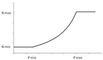 Figure 1